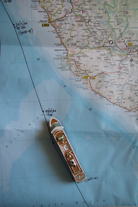
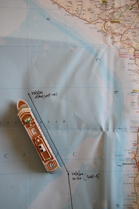
We awoke at 8:15 a.m. and wondered why everything was so quiet. When we went to the ship’s navigator system we saw that we had crossed the Tropic of Capricorn and entered GMT – 4 during the night.
Breakfast in the room was delicious, in fact the coffee was better than in the restaurant!
Our journey northwards close to the coast of South America follows the route of the Humboldt (or Peru) Current. This is a cold mass of water that has its origins in the South Pacific where the waters from the Southern Ocean mix with the waters of the Pacific. It is named after the naturalist Alexander von Humboldt who identified the currents of cold water and its direction of travel. Along its journey there is a circular movement in the ocean which brings nutrients to the surface which provides food for fish. We have seen shoals of fish very near the surface some of which have been eaten by seabirds as they skim the surface. This mixing of the upward movement of the cold water is even greater around 4° S where the Humboldt mixes with the warmer waters of the Tropics. Here is a fishing ground that accounts for 20% of the total world wide catch of sea fish. The fish caught are mostly pelagic (close to the surface) and are mostly sardines, anchovies, mackerel, tuna and hake. Until the 1980s this fishing ground had a longstanding rival at the Grand Banks off Newfoundland, Canada. These fishing grounds were famous for their cod, originally caught by the Portuguese and British from the 17th century until its closure in the late 20th century to conserve stocks.
The cold current cools the marine air off the coast of Chile, Peru and Ecuador. This produces little rainfall and hence the arid lands of the three countries. The most notable of these is Chile and its Atacama Desert. The town of Calama was until the early 21st century the driest town on earth where for 150 years rain had never been recorded. The record was shattered by a few millimetres of rainfall but it is still a very dry place.
The world’s oceans have many currents both warm and cold which makes the air above them move in the same consistent direction. Because of this consistency sailing ships involved in international trade used these currents and moving air to navigate the world, hence the term ‘trade winds’. So leaving Europe captains would navigate their ships into the northeasterly trade winds which would take them to the Caribbean. After a period of light winds in the Tropics the northwesterly trade winds would get them to Australia. Similar winds would enable them to return to Europe. This is an example from the Atlantic, the other oceans have similar patterns.
The Captain has informed us that we are aiming to rendezvous with the sister ship Rotterdam during the early evening of the 26th off the Panama Canal. They will be able to top us up with supplies and anything virus related should it be needed as they have done with the Eurodam and Oosterdam off Mexico.
Negotiations are still taking place with the US State Department and other Foreign Offices.
To add to the excitement the first alert alarm sounded this afternoon. It turned out to be a small fire in the ironing section of the laundry on Deck A. We were on alert but no need for life vests. Another unexpected moment in this year’s Lisle tour.